12/29/2012

หน้าจอแสดงผล, Interface

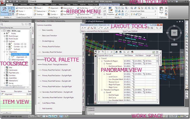
    หน้าจอแสดงการใช้งาน AutoCad Civil 3D รุ่นหลังนับตั้งแต่มีการปรับการใช้งานของ Microsoft 2007 ที่มีการปรัปรุุงการใช้งานเป็นแบบ Ribbon ทาง Autodesk มีการปรับปรุงการใช้งานให้มีลักษณะการใช้งานที่เหมือนกัน เมื่อเปิดการใช้งานหน้าจอแสดงผลรูปแบบและเครื่องมือระหว่างการใช้งานจะแสดงตามรูปด้านล่าง

   Interface using AutoCad Civil 3D generation since the use of Microsoft 2007 with the menu to use a ribbon by Autodesk to optimize the usage. the same. When enabled, the display format and the user is shown below.
                              User Interface 2

1. Menu Toolbar
     ชุดรายการคำสั่งทีเป็นเมนูให้เลือกใช้ที่สามารถย่อ(ซ่อน)หรือขยาย Ribbon menu มีให้เลือก Minimize to Tabs, Minimize to Panel title,Minimize Panel to Buttons


2. Ribbon Menu
      แถบ Menu แสดงการใช้งานคำสั่งการสร้าง Drawing จะรวบรวมคำสั่งไว้แต่ Panel เมือเลือกคำสั่งการใช้งานแถบ Ribbon จะแสดงคำสั่งย่อยออกมาให้ใช้งาน


3.Layout Tools
     ชุดคำสั่งการใช้งานที่ออกมาจาก Ribbon menu สำหรับสร้าง Drawing แต่ละรูปแบบของ Point, Surface, Alignment, Profile ชุดคำสั่งนี้อยู่บนหน้าจอสามารถใช้คำสั่งได้ปกติสำหรับการทำDrawing


4. Toolspace
    ชุดเครื่องมือใช้งานรวบรวมแหล่งข้อมูลที่ใช้ในการทำ Drawing ประกอบด้วยแถบป้าย (Tab) จำนวน 4 แถบดังนี้
   4.1 Prospector แถบหน้าต่างตรวจสอบข้อมูลระหว่างใช้งานจะปรากฎขึ้นในส่วนนี้ ข้อมูลจุดสำรวจที่นำเข้า ข้อมูลที่สร้างขึ้นจาก Surface, Alignment, Corridor, Assembly
   4.2 Setting แถบกำหนดตั้งค่ารูปแบบการใช้งานการออกแบบพื้นที่หรือการออกแบบถนน
   4.3 Survey แถบกำหนดการใช้งานทางด้านสำรวจ
   4.4 Toolbox แถบการใช้งานข้อมูลที่ได้จากการประมวลผลเพื่อนำมาเปรียบเทียบและใช้งาน

A set of tools and sources of information used in making the label tab, the following.

    4.1 Prospector tab window, check the application will appear in this section. Information on the survey. The data generated from the Surface, Alignment, Corridor, Assembly.

    4.2 Setting to set the pattern for the furface or the road design.

    4.3 Survey tab the schedule for the survey data.

    4.4 Toolbox to use the information obtained from the processing to be compared and used.


5.Toolpalettes
     ชุดเครื่องมือออกแบบหน้าตัดส่วนประกอบโครงสร้างถนน Subassemblies ที่นำมาประกอบเข้าด้วยกันให้เป็นรูปหน้าตัด Medain, Lane, Shoulder,Sidewalk,curb,side slope


7. Panorama
     หน้าต่างที่แสดงออกมาของข้อมูลบางอย่างที่เลือก สามารถเลื่อนติดด้านข้าง(Allow-Docking)หรือซ่อนการหน้าต่าง(Auto hide)ได้ตามที่กำหนด


8.Item View
   หน้าต่างแสดงผลของข้อมูลที่เลือกจาก Prospector tab อาจเป็น จุดสำรวจ Survey Point หรือ Description key จะแสดงขึ้นใต้ Toolspace ซึ่งสามารถที่จะแก้ไขข้อมูลตามรายการในช่องของข้อมูลนั้น


9.Properties
   ในการเลือกวัตถุใดหรือต้องการปรับแก้ จากคำสั่ง Command : MO จะปรากฎ Properties ขึ้นเพื่อปรับลักษณะของวัตถุ


10. Workspace
     ชุดคำสั่งการทำงานที่อยู่ด้านล่างสุด แสดงคำสั่ง Model, Layout, Scale,และเลือกการใช้งานระหว่าง AutoCad


12/25/2012

โซน 47, ZONE 47

       การใช้งานในแผนที่ของในประเทศไทยปัจจุบันได้มีการนำระบบเทคในโลยี่สารสนเทศน์มาใช้ร่วมกันในองกรค์ ซึ่งการทำแผนมีการประยุกค์หลายองค์ประกอบเข้าด้วยกันทั้งในงานสนามและการใช้ภาพถ่ายทางอากาศ ใน AutoCad Civil 3D รุ่น 2010 และ Civil 3d 2012 ได้มีการนำเอาภาพถ่ายทางอากาศจาก Google Earth เข้ามาทำด้านการสร้าง Surface ในการทำอาศัยหลักการยึดเส้น  Central Meridian เป็นหลัก ซึ่งเป็นสิ่งหนึ่งที่การแบ่ง Zone เข้ามาเกี่ยวข้องในการใช้ AutoCAd Civil 3D

การกำหนดตำแหน่งในแผนที่
1. กำหนดตำแหน่งพิกัด ทางภูมิศาสตร์ (Geographic Coordinate)
2. กำหนดตำแหน่งพิกัด กิจการทหาร ( Military Gride Coordinate)

                      image
                                                UTM Grid Zones of the WorldCompiled by Alan Morton
 
THE UNIVERSAL TRANSVERSE MERCATOR GRID
 
     ระบบเส้นกริดที่ตกลงนำมาใช้กิจการทหารของสหรัฐอเมริกาและได้มีการตกลงกับร้ฐบาลไทยในปี ค.ศ.1953โดยใช้กับระบบการทำแผนที่ของโปรเจคชั่น TRANSVERSE MERCATOR PROJECTION ซึ่งเรียกว่า ระบบพิกัดฉาก เส้นกริดทั้งหมดของ UTM ที่ใช้กันทั้งหมดทั่วโลก ช่วงระหว่าง Latitude 80 องศาใต้ ถึง Latitude   84 องศาเหนือ ส่วนนอกเหนือจาก Latitude ของช่วงนี้ใช้ UPS Grid(Universal Polar Stereographic Grid)

การกำหนดแบ่งโซน UTM Zone  
 
     การแบ่งแยกโซนซึ่งถือว่าโลกมีทั้งหมด 360 องศา การแบ่งจะยึดเส้น Prime Meridian เป็นหลักออกไปทางตะวันตกช่องละ 6 องศา และมาทางตะวันออกช่องละ 6 องศาเช่นเดียวกัน โดยให้เส้นที่นับไปทางตะวันตก 180 องศา ที่บรรจบกับเส้นที่นับไปทางตะวันออก 180 องศา คือเส้น Antimeridian เป็นจุดเริ่มต้นของโซนที่ 1 กัน ซึ่งจะได้ทั้งหมด 60 โซน
                                   

     จุดตัดของโซนของเส้น ระหว่าง Longitude และ Latitude จะกำหนดที่ด้านนอน ที่เส้น Equator เป็นหลักมีค่า 0 เมตร สำหรับขึ้นทางด้านเหนือ(ค่าพิกัดจะเพิ่มขึ้นสู่ขั้วโลกเหนือ) และเท่ากับ 10,000,000 เมตร สำหรับลงทางด้านทิศใต้(ค่าพิกัดจะลดลงสู่ขั้วโลกใต้) และค่าของจุดตัดของเส้นย่านกลาง(Central Meridian)ของแต่ละโซน จะมีค่าเท่ากับ 500,000 เมตร ซึ่งจะเท่ากันทุกโซนทั้งตะวันออกและตะวันตกตั้งแตโซนที่ 1 ถึง โซนที่ 60 ซึ่งจะทำให้ค่าพิกัดทางตะวันออก(East) ทุกที่มีค่าแสดงเพียงหกหลักเท่านั้น

     การแบ่งโซนดังกล่าวจะเกี่ยวข้องกันกับเวลาที่นำมาใช้ร่วมกันในการกำหนดเวลา(Zone Time) ของแต่ละประเทศโดยอ้างอิงจากมาจากเส้นย่านกลางซึ่งจะทำให้หนึ่งชั่วโมงที่ค่าเท่ากับ 15 องศา


      การทำแผนที่ในประเทศไทยใช้ระบบเส้นโครงแผนที่ (Projection)ในการฉายภาพในการทำแผนที่แบบทรงกระบอกวางตัวในแนวขวาง  (Transverse  Mercator)  ซึ่งมีคุณสมบัติคงรูปร่าง ส่วนความเพี้ยนทางมาตราส่วน (Scale Distortion)  ที่เส้นเมอริเดียนย่านกลางจะมีค่าน้อยที่สุดคือ 0.9996 ซึงเป็นค่าที่นำมาทำการปรับแก้เพื่อให้รอยต่อเข้ากันพอดีในแผนที่

     การแบ่งเส้นดังกล่าวในการนำมาให้งานประกอบการเขียนแบบใน AutoCad Land Development หรือ Civil 3D ในการตั้งค่า ( Setting )จึงต้องเลือกระบบการใช้แผนที่และบริเวณพื้นที่อยู่ด้านเหนือหรือด้านใต้เส้น Equator ซึ่งจะเกี่ยวเนื่องกับการนำรูปแผนที่ส่งไปยัง Google Earth


UTM Zone ประเทศไทย
 
     ประเทศไทยจากการแบ่งระบบตามแนวเส้น อยู่ในช่วง Longitude 97 องศาตะวันออก ถึง 105 องศาตะวันออก การแบ่งโซนในประเทศไทยจึงมี 2 โซน คือZone 47 และ Zone 48
     Zone 47 กำหนดโซนเริ่มที่ Longitude 96 องศาตะวันออก ถึง Longitude 102 องศาตะวันออก Central Meridian 99 องศาตะวันออก ค่าพิกัด UTM เท่ากับ 500,000 เมตร
     Zone 48 กำหนดโซนเริ่มต้นที่ 102 องศาตะวันออก ถึง 108 องศาตะว้นออก Central Meridian 105 องศาตะวันออก ค่าพิกัด UTM เท่ากับ 500,000 เมตร

จังหวัดรอยต่อระหว่าง Zone 47 และ Zone 48

 จังหวัดที่มีรอยต่อของเส้นที่พาดผ่านการแบ่งโซนในประเทศไทยซึงจังหวัดเหล่านี้จะมีสองโซนในจังหวัดเดียวกันมีทั้งหมด 9 จังหวัด  ดังนี้
1.เลย                    2.หนองบัวลำภู (บางส่วน) 
3.ขอนแก่น            4.ชัยภูมิ                     
5.นครราชสีมา       6. ปราจีนบุรี
7.สระแก้ว              8.จันทบุรี
9.นราธิวาส (บางส่วน)


                                                      แผนที่จังหวัดที่รอยต่อระหว่าง ZONE 47, ZONE 48

    ZONE 47 – ZONE 48
     The map in the navigation system's Technology for helping to share in the organization. The plan is to apply eye several elements together, both in the field and the use of aerial photographs in AutoCad Civil 3D models 2010 and Civil 3D 2012 has been taking aerial photos from Google Earth into the side. Surface construction based on the principle of making the Central Meridian is one thing that is relevant to the Zone to the Auto CAd Civil 3D

The position on the map
1.Geographic Coordinate
2. A military positioning coordinates (Military Grid Coordinate).

THE UNIVERSAL TRANSVERSE MERCATOR GRID.   The grid system used by the military of the United States of America,and the Government has agreed to the content suppliers in Thailand. 1953 using the mapping of with TRANSVERSE MERCATOR PROJECTION called rectangular coordinate system.UTM grid lines, all of which use all the help from the Latitude 80 degrees south to Latitude 84 degrees North Latitude, the addition of this capacity during the UPS Grid.(Universal Polar Stereographic Grid)

The median zone UTM Zone.

     Zone which has separated the 360 ​​division is the Prime Meridian is the line west to the east and 6 degrees and 6 degrees at the same And to the west by a line from the intersection with a line that is 180 degrees to 180 degrees east is the Antimeridian the beginning of Zone 1, which is a total of 60 zones.
                              

     Intersection zone between the Longitude and Latitude of the line to the horizontal line at the Equator is 0 meter value for the equivalent of 10 million meters for the north and to the south. And the point of intersection of the middle line (Central  Meridian) of each zone. Is equal to 500,000 meters, which is equal in both eastern and western zones.

UTM  Zone In Thailand

     Thailand's system of dividing line in the Longitude 97 degrees East to 105 degrees East is divided in two zones, the zones, Zone 47 and Zone 48.
     Zone 47 to Zone Start Longitude 96 degrees East Longitude 102 degrees East to Central Meridian 99 degrees at UTM coordinates 500,000 meters.
     Zone 48 to Zone from 102 degrees east to 108 degrees to outputs the Central Meridian 105 ° east UTM coordinates 500,000 meters equal. This gives the coordinates of the east, all that is shown is only six digits only.

      The zones are associated with time to be shared in the zone time of each country, based on the central line, which makes one hours equals 15 degrees.

     Thailand system and map projection the projection mapping cylinder placed horizontally (Transverse Mercator Grid), which has a fixed shape. The distortion of scale at the central meridian is the smallest value is 0.9996, which is used to make adjustments to fit the map boundaries.

      These dividing lines are introduced to the assembly drawings in AutoCad Land Development or Civil 3D in the settings must select to use a map and location on the north side or the south side of the Equator, which is concerning. to the introduction of map publishing data to Google Earth


Provincial boundary between Zone 47 and Zone 48.

    Provinces with the boundaries of the zones across the province in which these two zones in all 9 provinces are the same.


1. Lei                            2. Nong Bua Lum Phu(Partial)
3. Khonkhean               4. Chaiyaphum
5. Nakornratchasima    6. Prachinburi
7. Sakaeo                      8.Chanthaburi
9. Naratiwat(Partial)


12/21/2012

งานสำรวจก่อสร้าง Apron,( Apron Survey Construction )

     การกำหนดตำแหน่งขุดเปิดหน้าดินและการวางตำแหน่ง Apron  ในการทำฐาน Apon ชุดสำรวจเข้าดำเดินการโดยการทำหมุดโยงยึดหมุดจากหมุดของ JICA หมายเลขหมุด HM-JA1 เป็นจุดตั้งกล้องและธงหลัง หมายเลขหมุด HMALB1 ทำการรังวัดแบบวงรอบเปิดรังวัดรอบหมุดเลือกบันทึกจำนวน 8 Set ซึ่งแต่ละ Set ค่าที่บันทึกแตกต่างกันไม่เกิน 10 Second ผ่านที่บริเวณที่ก่อสร้างไปเข้าบรรจบ JICA หมายเลขหมุด HM-JA 3 และบรรจบกับสถานีสุดท้ายที่ HM-JA 4 มีจำนวน 5 หมุด นำค่ามุมที่ได้จากการรังวัดมุุมในสนามทำการคำนวณโดยการใช้โปรแกรมคำนวณวงรอบแบบ Excel พร้อมทั้งคูณด้วยแก้ด้วย Scale Factor มีค่าเท่ากับ 0.999857775 เข้ามาปรับแก้ระยะทางที่ได้จากในสนาม ทำการคำนวณหาตำแหน่งพิกัดของสถานีและนำค่ามาใช้งานก่อสร้าง

     จากหมุดที 3 ตำแหน่งใกล้สุดกับบริเวณที่จะก่อสร้าง Apron ชุดสำรวจการใช้กล้อง Total Station ตั้งบนตำแหน่ง Station AP2 ใส่ค่าพิกัดหมุดตั้งกล้องและหมุดธงหลังที่ตำแหน่ง Station AP1ใช้ในการทำงานกำหนดขอบเขตของงานก่อสร้างซึ่งมีลักษณะรูปสี่เหลี่ยมไว้โดยรอบขอบเขตบริเวณก่อสร้าง และกำหนดเส้น Base line A ซึ่งอยู่ด้นข้างอยู่ติดกับ Taxiway ขนานไปตลอดแนวยาว Apron และอีกเส้นหนึ่ง Base line B ทำแนวตั้งฉากกับเส้นแรก อยู่บริเวณที่ติดกับแนว Existing Apron กำหนดกริดสำหรับงานขุดดินโดยทำการปักที่หมายทุกระยะ 10 x 10 เมตร ปักหลักที่ได้ทาสีไว้แล้วและเขียนค่าระดับความลึกที่ต้องการขุดไว้บนหลักไม้สำหรับควบคุมการขุดดิน

    สำหรับการกำหนดแนวเทคอนกรีตใด้มีการกำหนดไว้ตามแนว เส้น Base line A ได้มีการแบ่งระยะ 4 เมตร ใว้สำหรับแนว Cutting joint และเส้น Base line B ทุกระยะ 4 เมตร ตลอดแนวความกว้างของ Apron ซึ่งมีความกว้างกว่า Existing Apron ใว้สำหรับแนวเทคอนกรีต สุดแนวของคอนกรีต Bay สุดท้ายต่อดว้ยแนวของถนน Service Road ที่ใช้เชื่อมต่อระหว่าง Apron ไปยังอาคารผู้โดยสาร

     การดำเนินการของทีมสำรวจไทยระหว่างดำเนินการทั้งงานสำรวจทำวงรอบ งานสำรวจการก่อสร้าง Apon อยู่ภายใต้การควบคุมงานและตรวจสอบของอย่างใกล้ชิด จากเจ้าหน้าที่ปรึกษาและควบคุมงานจากเมือง เคปทาวน์ ประเทศแอฟริกาใต้


     To determine where to excavation the soil in the base Apron . The survey start to the traverse by the pins between the pins from the pins of the JICA number of pins HM-JA1 is the occupation and the back sight a number pins HMALB1 the traverse loop open. Surveying the pins a record number of 8 set each set the record doesn’t different than 10 Second, through the construction to the convergence JICA number of pins HM-JA 3 and converge to the final HM-JA 4. The data ​​obtained from the field survey calculated by using the Excel calculation of the traverse and multiplied by the scale factor is equal to 0.999857775 with the correct distance from the field. Calculate the coordinates of the Station and the data for construction.

    Of pins at 3 positions close to the site of the construction of Apron series explores the use of Total station, Total Station is occupy on the Station AP2 to installation coordinate of the pins and the flag for back sight at the Station AP1 in the scope of work, which have by a rectangular area around the area of the Apron and the trek to the Base line A which is adjacent to the long axis parallel to Taxiway and Apron Base line B to the line perpendicular to the first line. Located adjacent to the Existing Apron set by the excavation grid for every stitch is 10 x 10 meters and then settle down to paint and write the depth of the excavation on the main timber for the excavation.

     For determining the cement of any defined along the lines Base line A, the median length of 4 meters high for the cutting joint and the Base line B every 4 meters along the width of the Apron, which is wider than the Existing Apron. trust for the concrete. The Bay of concrete with the last line of the rabid Service Road to connect to the Terminal Apron.

     Implementation of the survey team conducted the survey Thailand during the cycle. Apron surveying construction is under the supervision and monitoring closely of the consultant from the Cape Town, South Africa.

                             The Consultant check the level compare with the existing Apron

12/18/2012

หนังสือ AutoCad Civil 3D

     หนังสือตำราศึกษาทางวิชาการหลากหลายสาขาวิชาทางความรู้ แก่ผู้สนใจในทางวิชาการทางด้านสาขาต่างๆ จะสามารถหามาศึกษาหาความรู้กันได้ไม่ยากนัก ซึ่งในแต่ละสาขายังแบ่งแยกออกเป็นหลายแขนงวิชาให้ผู้สนใจศึกษาค้นคว้าเพิ่มเติม
     หนังสือวิชาการที่เกี่ยวกับการคำนวณและออกแบบทางด้านวิศกรรม ในเมืองไทยที่มีเนื้อหาเกี่ยวกับการใช้งาน AutoCad Land Development และ หนังสือ AutoCad Civil 3D ในเมืองไทยมีออกมาได้หาน้อยมาก ทั้งที่หนังสือดังกล่าวในต่างประเทศสามารถหามาศึกษากันได้สะดวก ในเอเซียตะวันออกเฉียงใต้อย่างเช่น ประเทศเวียตนาม ระยะประมาณเกือบยี่สิบกว่าปีก่อนผู้สนใจสามาถที่จะหาตำรามาศึกษาเองได้มีตำรา Soft desk ที่แผยแพร่ให้ผู้สนใจได้ศึกษา บุคลากรของทางเวียตนามในช่วงนั้นจะมีความเข้าใจและสามารถที่จะใช้งาน AutoCad Land Development ได้ดีกว่าคนไทย และการศึกษาของคนที่นั่นการเรียนศึกษาต่อจะมีมากกว่าของไทยเป็นจำนานมาก ซึ่งถือว่าทางการและประชาชนเห็นความสำคัญของการศีกษา
     หนังสือ AutoCad Civil 3D ของไทยที่เกี่ยวกับงานการออกแบบถนน ยังไม่มีออกมาทั้งที่มีอาจารย์หลายท่านที่มืความรู้และเชี่ยวชาญทางด้านนี้ ในหลายสถาบันที่สามารถจะเขียนตำราออกมาให้นักศึกษาและผู้สนใจได้ศึกษา แต่ยังไม่มีตำรานี้ออกมาเป็นอย่างทางการ ซึ่งแตกต่างกันกับตำราการใช้งานโปรแกรมทางด้านวิศกรรมหลายอย่างเช่น การใช้งานโปรแกรม AutoCad ของแขนงวิชาต่างๆ ที่มีตำราออกมาหลายเล่มทำให้มีจำนวนผู้ใช้งานเป็นจำนวนมาก สำหรับผู้ที่สนใจศึกษาหาความรู้การใช้งานโปรแกม AutoCad Civil 3D ต้องหาแนวทางที่จะสามารถใช้งานโปรแกมจากแหล่งวิชาที่มีหลายช่องทางให้ศึกษาหาหาความรู้
     Civil 3D ถือว่าเป็นโปรแกรมที่เหมาะสมกับ การออกแบบถนน Road Design มีฟังชั่นการใช้งานสะดวกและรวดเร็ว สามารถตวจสอบและปรับแก้งานทันที่ รวมทั้งการคำนวณงานปริมาณงาน และวางแผนงานในการก่อสร้างงานโครงการ การออกแบบถนน Civil 3d นับว่าช่วยให้การออกแบบของวฺิศกร ช่างสำรวจ ผู้เขียนแบบมีความสะดวกในการทำงาน
     สำหรับผู้สนใจที่จะศึกษาทางด้านนี้ Civil 3d จะมีรูปแบบขั้นตอนการใช้งานต่อเนื่องกันไปตลอด ผู้ศึกษาถ้าได้ทำความเข้าใจขั้นตอนการใช้งานแล้วก็จะใช้งาน AutoCad Civil 3D ได้โดยที่ท่านยังไม่มีหนังสือตำราการใช้โปรแกรม Auto Cad Civil 3D ของเมืองไทย

                                    หนังสือ Soft Desk เวียตนาม,   Soft desk textbooks,Viet Nam

AutoCad Civil 3D textbooks in Thailand.
   Academic studies textbooks multidisciplinary knowledge. Those interested in the technical areas. It can not find it hard to learn. Each branch is divided into a number of fields to do more research.
    Scholarly books relating to the calculation and design engineering. In Thailand that are related to the use of Auto Cad Land Development and Civil 3D in Thailand have come out a little more. The book is a study abroad can find them easily in Southeast Asia, for example. In Vietnam, Soft desk textbook published nearly twenty years ago, if you can find texts that have been studied to distribute the books to study. People of Vietnam will have the understanding and ability to use Cad Land Development. And education of the students at that school than in Thailand, as it is very long. Which the public and the importance of the study.
     AutoCad Civil 3D Thailand's books about the road. No to all the teachers are giving you the knowledge and expertise in this field. In many institutions the ability to write texts and the students who do not study. This book does not come out as an official. The texts vary with the application such as engineering. AutoCad applications of these fields. There are several texts that have a large number of users. For those interested in learning the AutoCad Civil 3D can be used to find the way from the study subjects with multiple channels for knowledge.
     Civil 3D is a program that is appropriate for the Road Design. The easy-to-use functions to verify and correct the work immediately. Including the calculation of the amount of work, and planning of the road construction projects.For those interested in the study of the Civil 3D to form a continuous process throughout. If students understand the process of use.The user can use AutoCad Civil 3D,Before have textbooks to use AutoCad Civil 3D.in Thailand.


12/14/2012

โปรแกรมออกแบบ, Civil 3D Software

    การออกแบบทางวฺิศกรรมโยธาเป็นงานที่มีรายการที่ต้องทำรายการคำนวณหลายขั้นตอนสลับซับซ้อน ซึ่งต้องใช้เวลานานในการคำนวณกว่าจะได้ผลลัพธ์มาทำการวิเคราะห์วางแผนงาน รวมทั้งนำข้อมููลมาทำการก่อสร้างและควบคุมงาน
    ในชว่งเวลาที่ผ่านมาการสร้างพื้นผิวสำหรับการออกแบบดั้งเดิมนั้น มีโปรแกรมการใช้งานหลายอย่างที่ใช้ในการทำการประมวลผล ซึ่งใช้กันกันส่วนน้อยอยู่ในวงกำกัดใช้กันอยู่ในอาทิเช่น Geocom Surfure Solfdesk Land Desktop2i, Autodesk Land top Development และ Civil 3D
     ประมาณก่อนปี ค.ศ.2000 การใช้ Auto Cad จะเป็นรุ่น Auto Cad R14 การใช้งานจะเป็นการใช้ Command ซึ่งยังไม่สะดวกสำหรับผู้ที่ใช้งานจึงมีผู้ใช้งานกันเป็นส่วนน้อย ของ Auto Desk จะเป็น Soft Desk 8 ซึ่งจะแยก Module ออกจากกัน การใช้งานในช่วงนั้นจะต้อง Load การใช้งานขึ้นมาเฉพาะการใช้งานแต่ละงานแต่การทำงานยังร่วมกัน ซึ่งคำสั่งทั้งหมด Run on AutoCad
     หลังปี ค.ศ. 2000 AutoCad ได้พัฒนามาเป็นรุ่น 2002 และของ Auto Desk ได้พัฒนามาเป็นรุ่น Auto Cad Land Development 2i ในช่วงนี้การใช้งานกันมากขึ้น และในปี ค.ศ.2004 มาเป็น AutoCad Land Development 2004 ในช่วงนั้นถือว่าได้รับความนิยมมาก รุ่นถัดมา Version 2005 และถัดมาเป็น Civil 2006(รุ่นเริ่มต้นที่ไม่ใช้ Create project) และมาสิ้นสุดใน  Land Development 2009 และกลายมาเป็น Civil 3d 2010 ที่สามารถทำงานร่วมกับข้อมูลทางสาระสนเทศน์ และรุ่นที่ได้รับความนิยมในปัจจุบัน รุ่น Civil 3d 2012
      Civil 3D โปรแกรมการออกแแบบทางวิศวกรรมโยธาในปัจจุบันนี้ได้รับความนิยมมากซึ่งสามารถใช้กับงานหลายด้นที่ต้องการสร้างพื้นผิว ไม่ว่าจะเป็นงานทางด้านชลประทาน เหมืองแร่ เขื่อน สนามบิน และที่เหมาะมากใช้ การออกแบบถนน (Road Design) ซึ่งจะได้รับความสะดวกในนำข้อมูลที่ได้จากการสำรวจนำมาการทำรายการคำนวณออกแบบให้ถูกต้องกับหลักวิศวกรรม การคำนวณปริมาณงาน รวมทั้งการนำข้อมูลที่ได้ไปใช้วางแผนงานและดำเนินการก่อสร้าง

     Design Civil Engineering is a to-do list to calculate a complex process. It takes a long time to calculate the results will be used to analyze the plan. Also take down the information on the construction and supervision.
     During the time since the original design surface. There are many applications that are used in the process. Which used to be in the minority, such as restricted use in Geocom Surfure Solfdesk Land Desktop2i Autodesk Land Desktop and Civil 3d.
     Before about 2000, it is the use of AutoCad Auto Cad R14 applications will use Command, which is not easy for a user to be a part of the Auto Desk Soft Desk. Module 8, which are separated from each other during the Load will be used only for the individual but also to work together. All orders that Run on Auto Cad.
      After year 2000 Auto Cad version 2002 and has evolved into a model developed by Auto Desk Auto Cad Land Development 2i during the rise and in 2004 as Auto Cad. Land Development 2004 is considered as the most popular versions to version 2005 and later a Civil 2006(Non create project) and the end of the Land Development 2009 and became a Civil 3d 2010 to work with content data for helping. And the current version of the popular Civil 3d 2012.

     Civil 3d mode on the application of modern engineering has been very popular with a lot of work, which can be used to create surfaces. Whether it is the irrigation, mining, dams, airports, Road Design and very suitable for design analysis. Which will be located in the data obtained from a survey carried out to calculate the correct design and engineering. Computing workloads. The data obtained from the planning and construction process.

การก่อสร้างลานจอดเครื่องบิน Apron Construction

      งานโยธาการก่อสร้างเป็นการดำเนินงานที่เราเห็นได้ทุกที่ มีหลายรูปแบบที่ดำเนินการ ไม่ว่าทางด้านการพัฒนาสาธารณูปโภคบริโภค งานก่อสร้างอาคาร งานก่อสร้าง ถนนหนทาง งานก่อสร้างอาคาร รวมทั้งงานก่อสร้างสนามบิน
       การก่อสร้างสนามบินจะมีการแบ่งรูปแบบออกเป็นหลายส่วน ในส่วนที่เป็นงานหลักจะมีงานการก่อสร้างอาคารผู้โดยสาร หอบังคับการบิน อาคารสำนักงานส่วนต่างๆ ในส่วนของงานสนามจะลานจอด
รันเวย์ และแท็กซี่เวย์ ในส่วนของการก่อสร้างลานจอด ขั้นตอนการก่อสร้างสนนามบินนานาชาติจูบา ซูดานใต้ แอฟริกาตะวันออก ซึ่งทีมงานคนไทยใด้ดำเนินการก่อสร้างและควบคุมการดำเนินงาน ตามขั้นตอน ดังนี้

งานสำรวจ
     ทีมงานสำรวจเข้าปฏิบัติงานค้นหาหมุด จุดสำรวจ(Survey Point) โดยอาศัยข้อมูลเดิมที่มีหมุดหลักฐานในสนามที่ดำเนินการในครั้งแรกของทาง JICA ซึ่งเหลืออยู่บริเวณตอนท้ายของ Runway และในตอนกลางของ Taxiway ในการค้นหาอาศัยเครื่องรับสัญญานแบบมือของ Garmin รุ่น 60 CSx แล้วโยงหมุดหลักฐานเข้าหากันเพื่อดำเนิการตรวจสอบและนำค่าที่ได้มาใช้งานในการก่อสร้าง

งานดำเนินการก่อสร้าง
1 ขุดเปิดขนย้ายดินให้ได้ระดับตามแบบกำหนด
2. ถมวัสดุชั้นแรกเป็นหินก้อนขนาดประมาณ 30-50 เซ็นติเมตร
3. ถมลูกรังในชั้นที่สองและชั้นที่สาม
4. ถมหินคลุก
5. เทคอนกรีตหนา 34 เซ็นติเมตร
6. ตัดแนวเชื่อมต่อและยาแนวตามรอยตัด
 
Apron Construction
       Construction operations as we see them everywhere. There are many ways to take action. Whether developing utility consuming,building construction, road construction. The construction of the Airport.
       Construction of the Airport will be divided into multiple formats in descending order in the primary task. The task of building occupants control tower. Building parts. In the site a lot of the Rrunway and the Taxiways.
     The construction of the Apron. The process of construction of Juba International Airport, Juba capital, South Sudan in East Africa. The Thailand team to make the construction and operations as follows.
Survey.
     Survey teams to perform search based on the original data with Survey Point The point evidence in court at the time of the JICA remaining at the end of Runway and in the middle of Taxiway to find the BM. by the handy GSP. of a Garmin Model 60 CSx and link pins evidence together to black. To determine the origin and has been used in the construction.
The construction process.
1.Excavated soil is transported to a designated level.
2.Rock fill material prior to loading on the first floor.
3. Laterite in the second layer and the third layer is about 60 centimeters thick.
4. Crunch rock layer
5. Concrete 34 cm thick.
6. Across the grout on the track.


                                               Excavation foundation of apron slab

12/13/2012

การขยายสนามบิน The expansion of the Airport


     ทวีปแอฟริกาเป็นทวีปที่มีอารยะธรรมละทรัพยากรหลายอย่างที่อุดมสมบุรณ์ไม่ด้อยไปกว่าทวีปอื่น ซึ่งอารยะธรรมอันเก่าแก่ดั้งเดิมของโลกมีต้นกำเนิดที่นี่ ไม่ว่าจะเป็นปิรามิดที่ตั้งอยู่ในประเทศอียิปที่ติดอัน 1 ใน 7 ของโลก รวมทั้งแหล่งอารยะธรรมแห่งอื่นและหลายเมืองในทวีปนี้เป็นเมืองที่มีการตั้งถิ่นฐานที่มีการออกแบบวางผังเมืองมาตั้งแต่ยุคเก่าก่อน การวางตัวของเมืองจึงสวยงามติดอันดับเป็นเมืองน่าท่องเที่ยว  อีกทั้งมีทรัพยากรทางธรรมชาติอันหลากหลายที่ว่านี้ประกอบไปด้วยขุนเขายอดคีโบที่มีความสูง 5,895 เมตร ลักษณะเป็นภูเขาไฟยอดเดี่ยวที่สูงที่สุดในโลก แม่น้ำไนร์ซึ่งเป็นแม่น้ำแห่งทวีปที่มีต้นกำเนิดที่อูกานดาระยะทางการไหลอันยาวไกลผ่านหลายประเทศในภูมิภาคนี้ อีกทั้งหลากหลายทางสัตว์ป่าธรรมชาติอันขึ้นชื่อลือเลื่องของซาฟารีที่ติดอันดับหนึ่งของโลก
     ในภูมิภาคแอฟริกาตะวันออกการเดินทางของนักท่องเที่ยวและนักธุระกิจที่ต้องเดินทางมาที่นี้มีจำนวนมากไม่ด้อยไปกว่าภูมิภาคอื่น จำนวนของผู้เดินทางนี้เพิ่มข้ึนเป็นประจำทุกปี เป็นเหตุให้สนามบินหลายแห่งไม่เพียงพอบริการแก่ความต้องของผู้โดยสารที่เดินทางมา จึงมีการขยายสนามบินเพื่อเป็นศูนย์กลางการบิน รองรับปริมาณสายที่เพิ่มจำนวนมากขึ้น และสามารถที่จะรองรับเครื่องบินขนาดใหญ่จากแดนไกล โดยในส่วนของการขยายหลายแห่งได้มีการขยายอาคารรองรับผู้โดยสาร รันเย์ แท็กซี่เวย์ Apron
     
Africa is a continent with many resource-rich civilization at the Bush invited no less than another continent. The original ancient civilizations of the world have their origins here. A Pyramid located in E. Yip, that's 1 in 7 of the world as well as sources of civilization in other cities in the region of its settlement with the city planning to. Since the old. The rest of the top is a beautiful city to visit. There are a variety of natural resources that is comprised of a high mountain in the world's top fun.Mount Kilimanjaro is the highest peak in Africa, is 5,895 m high. As a single peak, the highest volcano in the world. North of the river Nile, which originates at the Uganda taking the long distance runs through several countries in the region. The diversity of natural wildlife safari's widely known as one of the world's busiest.

     
In the East African region, the flow of tourists and businesses to come here with a lot less than other regions. Increased number of travelers is increasing every year. As a result, many airports do not adequately serve the needs of passengers traveling. The airport has been extended to the aviation hub. Accommodate the increased number of calls. And able to accommodate large aircraft from afar.
In terms of expanding the number of passengers has been extended to buildings  runway Apron taxiways and the terminal.
                สนามบินนานาชาติ กรุงไนโรบี,เคนยา Jomo Kenyatta International Airport,Kenya